Urban Land Ownership Mapping in Copenhagen
Towards radical transparency — between liveability, affordability, and polycrisis
This 2nd blogpost of the series marks the next milestone in the collaboration between Dark Matter Labs and the Institute of Human Rights and Business (IHRB), to increase transparency regarding the largest urban landowners in four European cities (see: Blog 1 explaining the project purpose). This study mapped land ownership in Copenhagen (as of August, 2023) aiming to reveal the largest land owners, patterns in management of land, and resulting power dynamics in city space production.
Through these findings, we also suggest initial ways forward with regards to city space production and ownership transparency. We would love to hear your views.
Summary (short read)
Transparency is a cross-cutting human rights principle, which helps to strengthen decision-making to enable better outcomes for people. IHRB is partnering with Dark Matter Labs to identify the largest owners of urban land in four European cities, as part of its project Building for Today and the Future. This recognizes that knowledge of who owns space within a city is one important step (in tandem with many others) to strengthen decision-making, as well as social and environmental outcomes.
Copenhagen is known for its high quality of living, deeply rooted culture of public welfare and participation, resistance to speculative foreign investments as well as rich urban planning and architectural scene: it is often held up as an example of equitable space production and a “liveable” city. However, in the recent decades, the dismantling and restructuring of the Danish Welfare State and private-led urban development patterns have contributed to Copenhagen’s high levels of unaffordability, as well as spatial disparity and discrimination. Across Danish cities, the housing cost overburden (reflecting housing cost as a share in disposable income) is the second highest in Europe (see also the Right to Dwell — Un-liveability Trends, KADK 2018).
→ Data transparency and accessibility in Copenhagen set an example for other cities, as this information is relatively easy to access. However, from our research it is clear that, in contexts such as this, the understanding of the wider city political dynamics, institutional changes, and local actors’ strategic moves are as important, if not more, than the static accessible ownership data registers.
One might therefore want to call for an additional set of tools to increase the transparency and accountability for decision-making. Tools which unlock greater insights into areas such as:
- the reasons for value appreciation of land and properties (e.g. through public infrastructure development — see A Smart Commons);
- real estate transactions; and;
- their main beneficiaries.
As this might sound complex… the data, at least for Copenhagen, is largely there.
Accessibility to static datasets (or map interfaces — as the Little Mermaid fortunately resting on the municipal soil) sets a good ground for basic analysis of who owns what, which is still an impossible task in most cities.
However, extending the sensing infrastructures (civic and public) might render a possibility of updating the predominantly debt-driven land-value capture model → (see: OECD, 2022 & Cities for Free) to better serve the greater public and environmental good in the long-term.
The blog that follows shares:
1. The ten largest owners of land in Copenhagen, which include the municipality, City & Port Corporation (By & Havn I/S), and the public housing corporation FSB.
2. Three case studies, diving into the areas of Nordhavn, Lynetteholmen and Tingbjerg:
I. Municipal land
— land management with land-value capture model.
- C1. Nordhavn — From bankruptcy to the “most liveable city” & potentials for land-value-capture reform to serve greater good — the upscale neighbourhood in the northern part of the city managed by the City & Port corporation describes the land-value capture model giving a glimpse into further actors at play (private property developers, family-owned companies, pension funds)
- Landowners: City & Port corporation
II. New land
— mega projects
C2. Lynetteholmen — New Municipal Land, Mega Projects & Potentials for City-Region Coordination Capacity: the planned mega project of Lynetteholmen (a 280-hectare, artificial island development ) points to city region coordination issues and the logic behind future city development pathways.
- Landowners: City & Port corporation (largest owners)
III. Non-profit land
— Commodification of non-profit land and housing
C3. Tingbjerg — Non-profit Land, Socio-economic Indicators & Fight for Space in a social housing area, pointing to approaches to vulnerable neighbourhoods in Denmark.
- Landowners: Fsb & key developer Nrep
Concluding reflections
Methodology
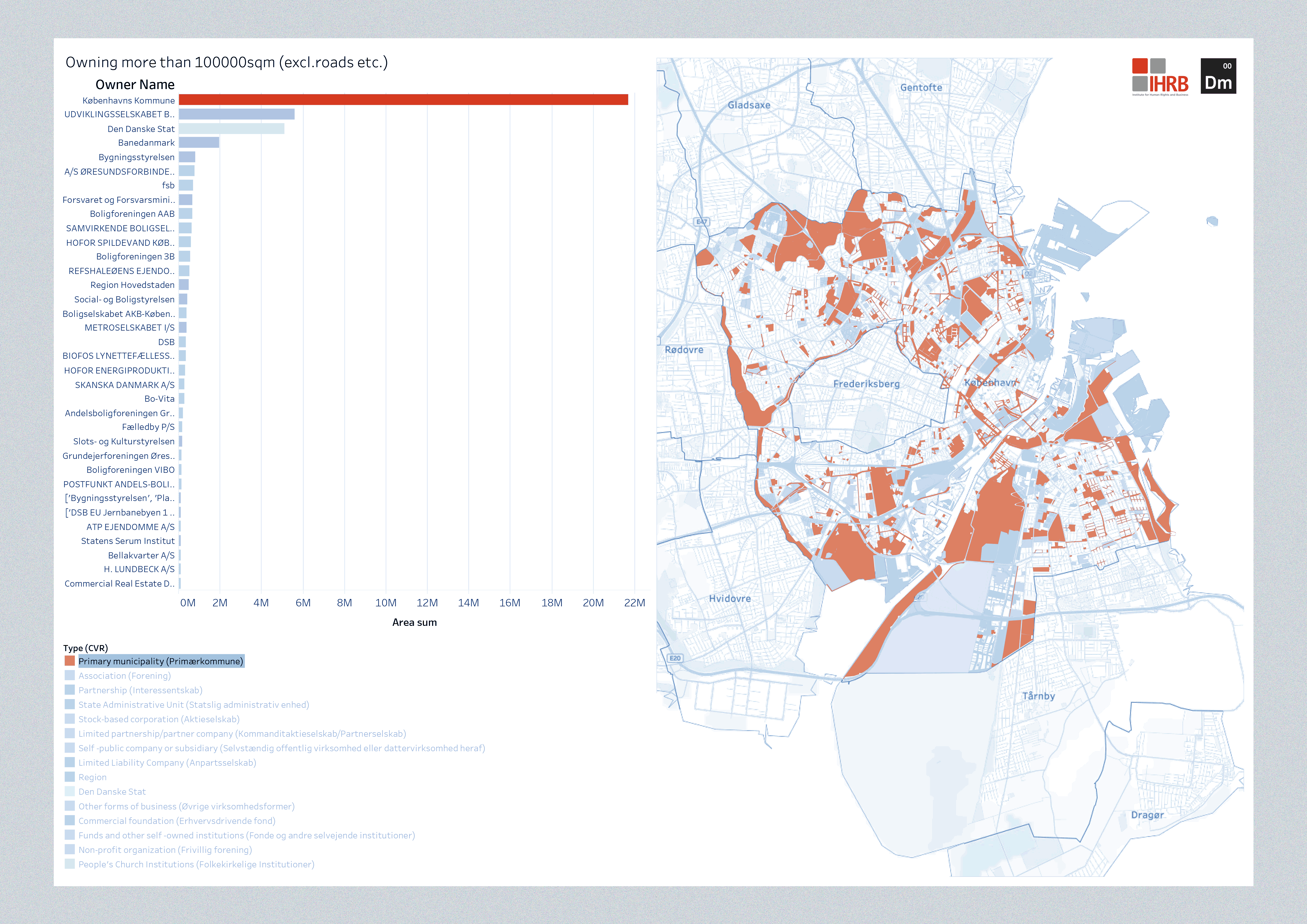
Largest landowners
1. Københavns Kommune — Copenhagen Municipality (KK)
2. By & Havn I/S — (City and Port Corporation — owned 95% by KK, 5% by the Danish State)
3. Den Danske Stat — Danish State
4. Banedanmark — Danish Railway
5. Bygningsstyrelsen — Danish Building & Property Agency
6. A/S Øresundsforbindelsen — owning land around the Øresund bridge and highways
7. Fsb — The largest public housing organization
8. Forsvaret og Forsvarsministeriets styrelser — The Ministry of Defence
9. Boligforeningen AAB — social housing organization
10. Samvirkende Boligselskaber (SAB) — Cooperative Housing Societies

Based on the case studies, examples of the most powerful land owning actors — defined as “needed in the room” to engage in an impactful discussion about shifting modes of Copenhagen’s development — include:
- By og Havn (described below), the Municipality and the Danish State
- Private developers such as Nrep (with Urban Partners ) — a real estate development company which manages one of Europe’s largest real estate funds and runs a platform with over 8 million square meters across eight countries. Engaged in developments in By og Havn projects (incl. Nordhavn) Tinbjerg development, and the “last plot of land for a new district development” — Jernbanebyen
- The largest (affordable) housing associations — FSB, SAB
- Other municipalities to coordinate a city-region planning approach (see: Fingerplan)
Note: further landowners can be easily identified based on available data sets.

3 case studies (long read)
In Dark Matter Labs, we often aim to design portfolios of strategic interventions as well as institutional capacities for democratization of common resources or civic & environmental good. Analogously, yet in contrast, in collaboration with IHRB, we looked at the set of policies, interventions & approaches that have defined urban land management in Copenhagen. Through this approach we can point towards a set of missing institutional and civic capacities required to update the way city space is produced in Copenhagen.
The purpose was not merely to complain or point fingers but to point towards a set of missing institutional and civic capacities necessary to update the way city space of Copenhagen is produced.
C1. Nordhavn — From bankruptcy to the “most liveable city” & Potentials for land-value-capture reform for greater good
Nordhavn — the upscale neighbourhood in the northern part of the city is a flagship project of the City & Port corporation.


C2. Lynetteholmen — New Municipal Land, Mega Projects & Potentials for City-Region Coordination Capacity

To further understand the reasons behind the push for developments described by many as risky, environmentally, and socially questionable one needs to zoom out and look at the Copenhagen Metropolitan Area as a whole, which includes 34 municipalities.
The famous Finger Plan once aimed to ensure the ecological diversity and functionality of the landscape by incorporated green belts with green wedges for recreational and environmental purposes, as well as a strategy for metropolitan expansion along 5 fingers in multiple municipalities. T he plan has been recognized as one of Europe’s best examples of far-sighted and long-term sustainable urban planning.
In 2015, the responsibility for the FP was handed over from the Ministry of Environment to the Ministry of Industry, Business and Financial Affairs, indicating economic growth as the main function of spatial planning . Apart from the city population growth and political pressures rooted in economic agendas, the green wedges and the structure of the Finger Plan have been challenged by the administrative division of power and interests of the neighbouring municipalities.
An emblematic example of the regional competition, rather than coordination in the Copenhagen Region can be another island development — Avedøre Holme, promoted by the Hvidovre Municipality, as Europe’s largest business district.
C3. Tingbjerg — Non-profit Land, Socio-economic Indicators & Potentials for New Definition of Liveability

Conclusion
Some of the key reflections include:
- One of the key insights from studying land ownership in Copenhagen — a place where data transparency and availability is exemplar, is that understanding the processes, institutional changes, and local actors’ strategic moves are as important, if not more, than the accessible ownership data registers.
- Despite some of the aforementioned trends, Copenhagen still remains a city with large amounts of land owned by the municipality and non-profit associations. This provides lots of scope for change in face of unaffordability and future cascading crises incl. the need for climate adaptation. Here, an update to the land-value capture model where climate risks are accounted for might be of value.
- The celebrated land-value capture model with multiplicity of its sub-mechanisms (infrastructure levy, developer obligations etc.) needs to be analyzed in its nuance. There are multiple forms of capturing value uplift and some might contribute to progressing unaffordability. For example unbalanced sale (by e.g. provision of affordable housing in the same area) of land to the highest bidder to repay infrastructure loans is still based on economic principles inadequate for the ultra-long term planning horizons cities need to look at in face of the cost of living crisis and climate adaptation necessities (see DML’s upcoming report with the Scottish Land Commission (link upcoming)).
- - The attempt of fixing spatial segregation issues with neoliberal means (via the sale of non-profit land, or commodification of non-profit housing) has proven to achieve the opposite, exacerbating city-scale spatial inequalities. Dissolution of the vulnerable neighbourhoods with the goal to create a “blended city” in the context of decreasing affordability indicators (Fig 1. are going down) may contribute to a) pushing the “problem” to other locations b) contributing to other forms of spatial segregation and c) nimbyism.
- Recognition of lack of institutional capacities to host alternative city and housing development models. The dominant debt-driven logic of the city and its infrastructure development which privileges premium price housing units is not only caused by the widely presumed single-mindedness of politicians or greed of developers. How the wider systemic context is structured sets a fertile pre-condition for this pattern: the financing sector, insurance, education and skills within municipalities or capacities to imagine alternative futures are just some of them.
- European, and global mobilization for sustainable, affordable and liveable cities. Copenhagen is a great city and one could argue if it became more inclusive and more affordable in the current globalized context, it would face even harsher population increases which eventually would prevent affordability.
- Lack of a long-term perspective — the greatness of Copenhagen is dictated not by the upscale starchitecture developments. It is the welfare state heydays stemming commons: the bikes, the open libraries with baby worlds, the work-life balance, the time to enjoy the good quality public spaces, the scale of the city, access to water, or Christiania neighbourhood in the middle of the city.
Finally, several complex questions which require further consideration came out of this initial investigation:
In addition to relatively transparent ownership & transaction databases:
- How can we increase political, societal sensing and sense-making capacities that allow us to foresee the socio-economic futures of the city based on ongoing developments e.g. on models such as land-value capture?
Responding to findings around Almene boliger / Tingbjerg
- What institutional infrastructures can be built to make citizens resilient to gradual institutional changes that may undermine their democratic mandate? (referring to Almene boliger)
Reflecting on the dominance of land value capture logic
- What other types of more equitable development models can be employed, if the neoliberal paradigm is a contributor rather than a cure to socio-economic urban issues (incl. spatial segregation) ?
- How can local and national policy, regulation, spatial planning & institutional capacities efficiently support and create favourable context for these alternative models to be efficiently deployed?
Some ways forward to explore — context specific (broked down above)
- Radical, dynamic land-value uplif transparency
- Capacity for new modes of governance of whole city-region land governance
- Capacity to sense policy and econmic activity effects on socio-economic indicators
Further, basing on DML, UNDP collaboration “A way Forward”:
- New national statistical offices (see p. 32)
- New, and radically trasparent digital infrastructures that enable “noun to verb” planning.
- The Open Sector — Data driven-transparency in companies (e.g. blockchain enabled) (see p. 36)
- Radical devolution of governance capacbilities enabled by digital interoperability (see p. 37)

Method & Data Transparency
The data gathering, analysis and mapping was performed and revealed owners of all plots larger than 2,000 sqm. It was conducted through a combination of methods including data requests from Datafordeler, and sourcing data OIS, BBR and Dawa API. The data was analysed and visualized in GIS and Tableau.
The transparency and accessibility of ownership data can set an example for many cities around the world.
Contact:
Aleksander Nowak aleks@darkmatterlabs.org
Annabel Short annabel.short@ihrb.org
Giulio Ferrini giulio.ferrini@ihrb.org
P.S. Graphic note: Land value capture model & possible upgrades (TBC)

